

Baddeck to Chéticamp, Sunday, 18-Jun-2023
We drove a sizable segment of the Cabot Trail. Along the way, we did a few hikes, including one that gave us a great view of fog and another where we got very wet.
Once again, we were trying to time our morning to hit a certain place, this time it was Ingonish for lunch. We packed our things, then went to check out. The person behind the desk helped give suggestions for things we could do that day as we drove the Cabot Trail.
The Cabot Trail is a large loop covering a large part of Cape Breton Island, and much of it is part of the Cape Breton Highlands National Park. We were starting at the southeast corner of the loop and would end about the midpoint of the west side. We will do more of the west segment when we head back to Halifax.
Broad Cove Mountain Trail
The first thing we did was drive a little past Ingonish to the Broad Cove Mountain Trail. Since we once again had fog along the way (at one point visibility was about 50 feet), we weren't sure how much, if any, of a view we would have of the water.
The trail is a continuous uphill climb, with many staircases. As we got higher, we started hiking into the fog. Fortunately, there were plenty of wildflowers along the trail to offset the lack of views.
At the top was a bench where you could sit to look at the view. For us, it was fog. Knowing that it's a risk when you only have a certain day and time to do a hike, so we figured we still got a good hike out of it and went back down to the car.
After putting things in the car, we returned the few miles to ingonish for lunch. That done, we returned to the Cabot Trail.


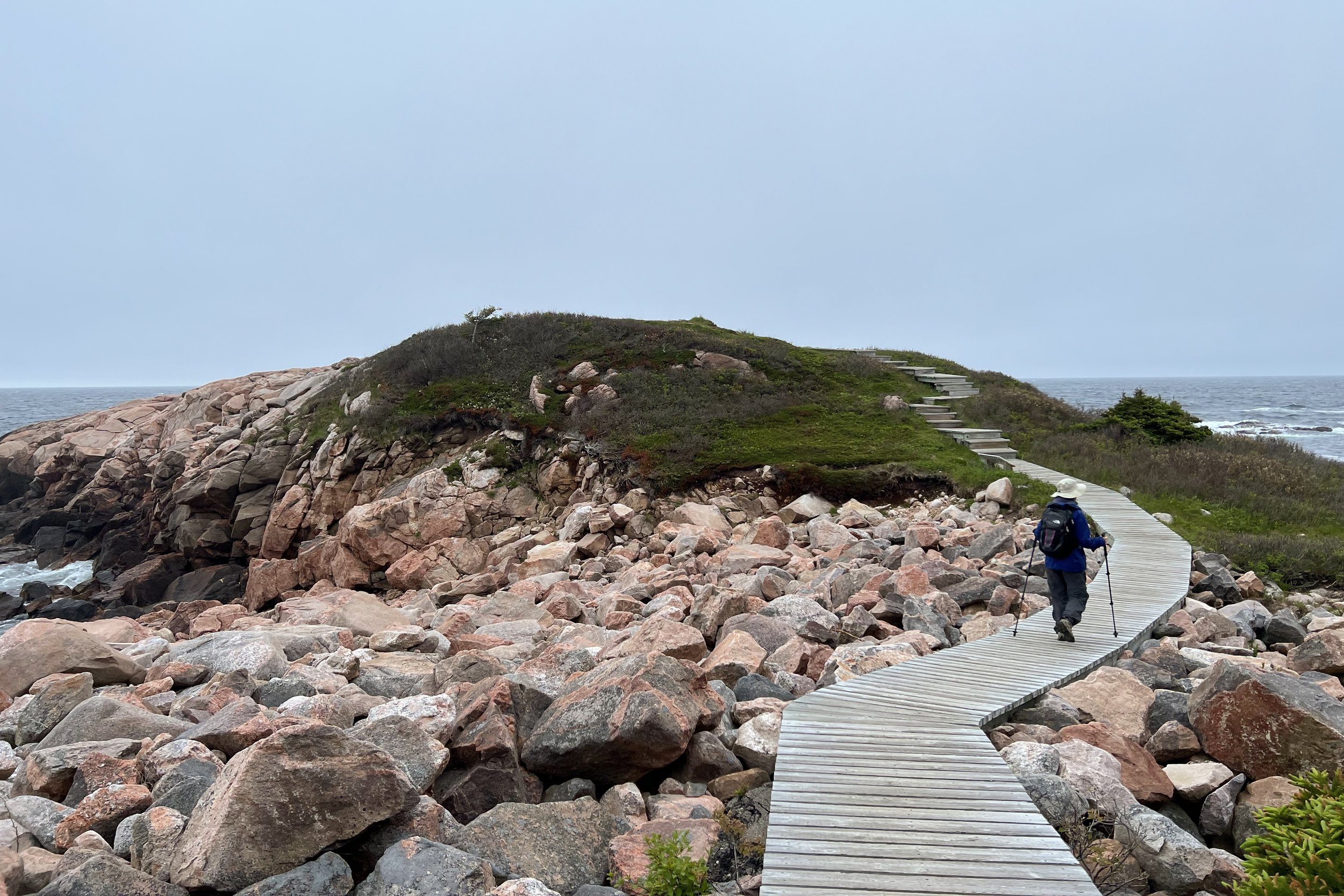
Green Cove
Not far beyond Broad Cove Mountain was Green Cove. There's a short boardwalk that leads you onto a headland where you can look at Green Cove to the north and Two Rock Cove to the south. Both the boardwalk below and the rock above gave great views of both.
Back at the parking lot, we saw another trail that went into the trees. At the end was a bench and a great view of the headland we were just on.


Jack Pine and Coastal Trail
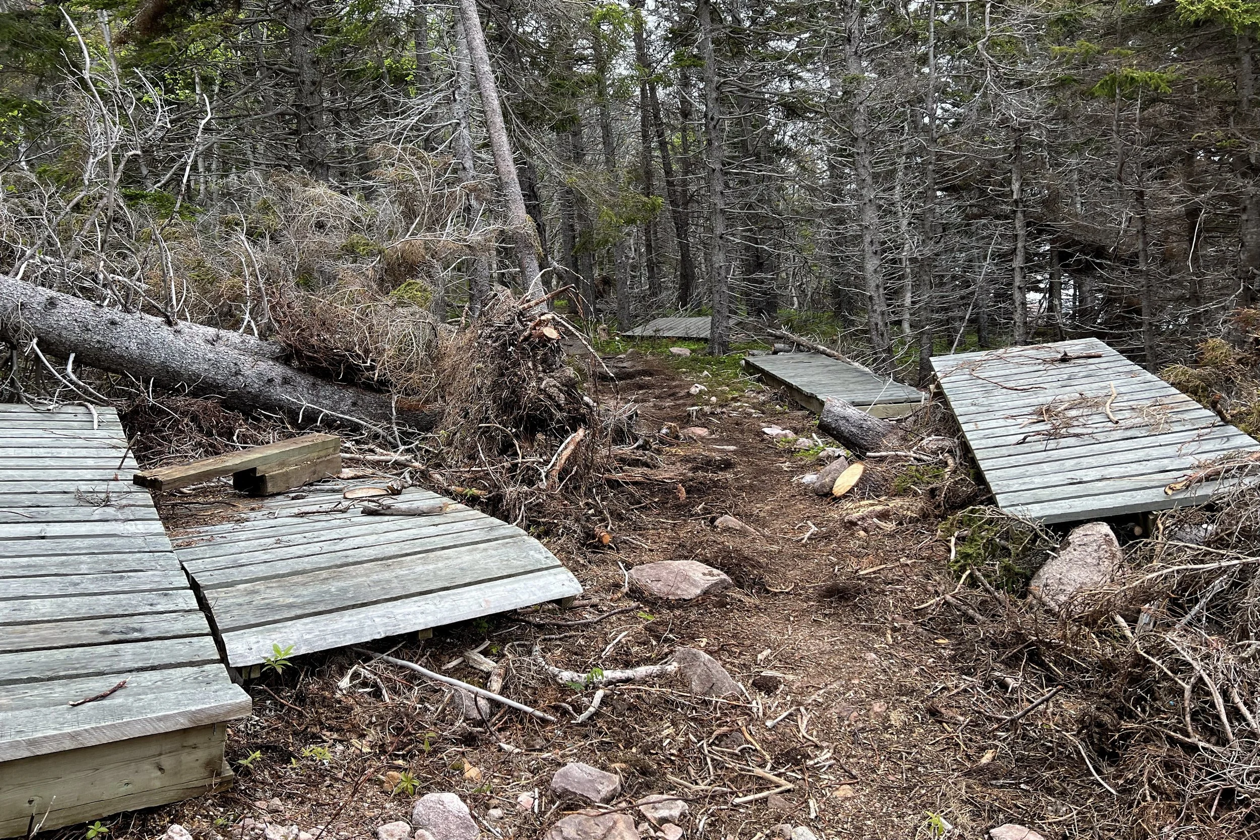
For this hike, we combined two trails, the coastal leg of the Jack Pine Trail and the part of the Coastal Trail that would loop us back to the trailhead. We knew we wanted to be on the Coastal Trail, but the choices were either the far north section or the far south section; the rest was damaged during Hurricane Fiona.
As we started, we saw a lot of reindeer moss on the rocks, but no Jack Pines. At one point we heard a cawing which was similar to a crow, but not quite; it was a raven. Soon after that, we saw some flying around. I happened to catch one landing on the top of a tree, then when it took flight again, other ravens joined it.
Shortly after seeing the ravens, we started seeing Jack Pine trees, and suddenly they were all over the place.
We came to a fork and figured we had found the connection with the Coastal Trail. Following it toward the water, we saw a bridge that was partially washed out, making it uncrossable. Continuing on the trail, we saw several sections of boardwalk piled on the sides of the trail; presumably, those were sections that needed to be replaced after the hurricane damage.
Debating whether we could see a trail, we saw where we needed to be a bit up a hill. We were able to cross some rocks, scramble up a few more, and make it to the path. After a turn, we found ourselves on the back side of a trail-closed sign. We weren't sure how we missed an earlier turnoff to the Coastal Trail, but we continued. Eventually, we got to a viewpoint and had great views of cliffs and coves with the tide splashing. It was brisk and windy.
Continuing on the Coastal Trail, we saw several more viewpoints, but it started to sprinkle. We had our hats and, if necessary, hoods on our raincoats, so it wasn't too bad, so we continued to find viewpoints. At each one, the rain increased, until it got to the point where we were getting pretty soaked. My phone and camera lenses were getting very wet, too, so I needed to wipe them off now and then. I still ended up doing some fixing up after I got the photos onto the computer.


We made it back to the car and started driving towards Chéticamp. The rain continued as we drove across the north end of the Cabot Trail, but by the time we got to the west side, it had stopped. The view was pretty amazing (as it was driving the entire day), and we made mental notes of places we would want to check out in the next couple of days.
Arriving at our motel, we got things out of the car, went across the street for groceries, then returned to the room to warm up and stay inside for the rest of the night.

