

Sequoia and Kings Canyon National Parks, 8–10 Oct 2022
Since Melody had a conference in Los Angeles in the middle of October, and we decided to leave a few days early to have some time in Sequoia and Kings Canyon National Parks. I hadn't been there since elementary school, and this would be Melody's first time. We did quite a bit of hiking, as well as many of the tourist favorites.
We flew into Fresno on Friday the 7th and picked up a car. Since we knew grocery availability would be scarce where we were staying, we shopped for food before leaving Fresno. We tried to get enough for most of our mornings, as well as for some hiking. After that, we drove east for a bit, then started on some very windy roads to get to our Airbnb. When we arrived, our host was out of town, but someone else was there to take care of the property.
We settled in and tried to get onto WiFi. It was a slightly different name than on the welcome sheet, and it's not as if houses were close to each other for it to be someone else's. It kept cutting in and out as if it was pretty far away from our unit. It was getting to be dinnertime, so we heated up some things we had gotten from the store. After that, the proper network showed up, and it was a lot stronger signal, so we were happy with that.
Saturday, 8-Oct
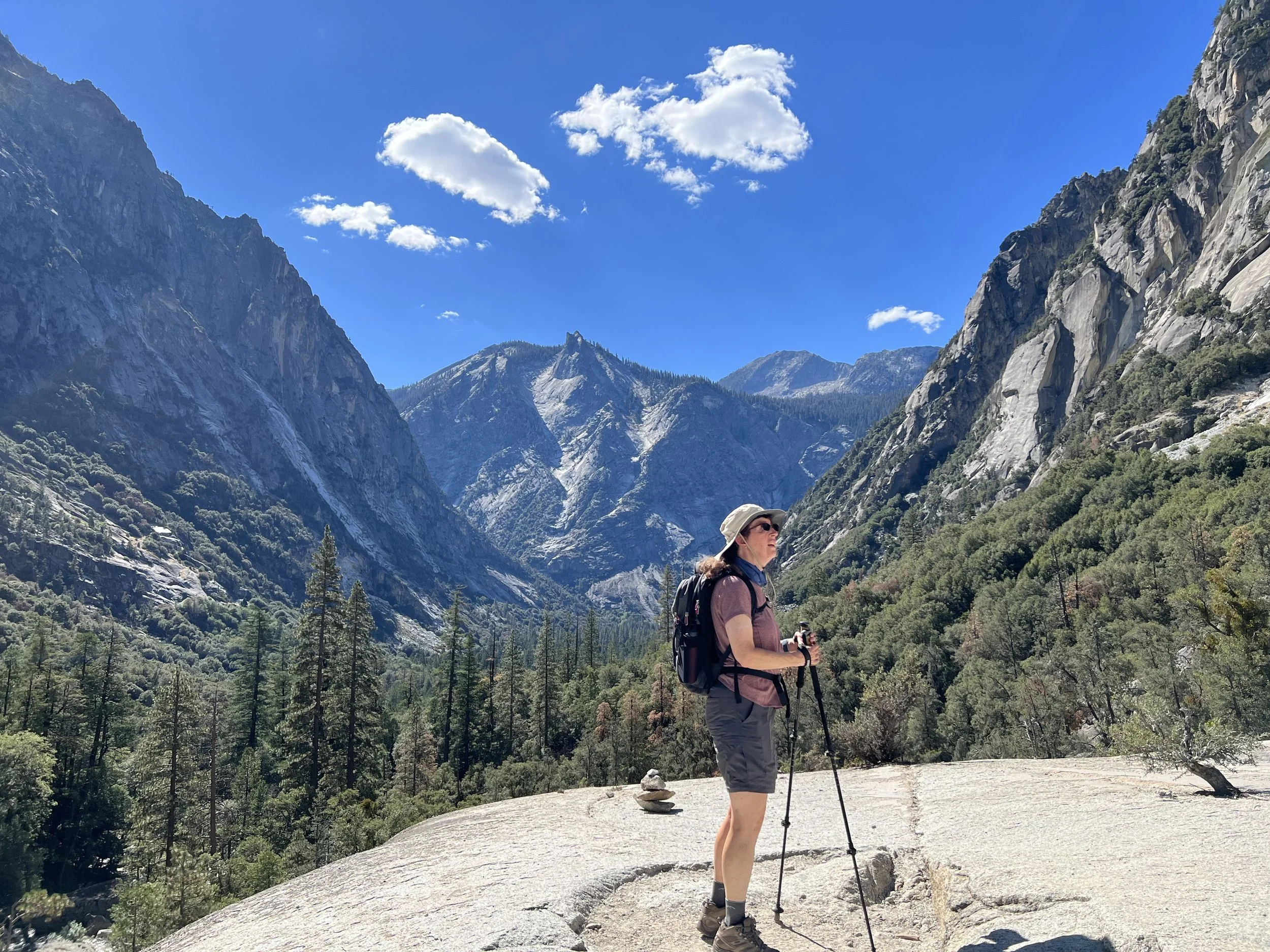
Since we were able to do so, we purchased our entrance pass while at home, so we wouldn't need to deal with it on the way in. Our plan was to do a couple of days with longer hikes and a less strenuous day in between. This was a longer hike day, and we decided to take the road into Kings Canyon until it stopped (to a place called Road's End) and hike to Mist Falls. The drive was about an hour and a half, so we would hopefully miss most of the big crowds.
The entrance to the park had only one kiosk open, and there was a short line to get in. The first car took quite a while, probably because they were asking the ranger several questions. The second car was fast, then just in front of us was a group of three motorcycles. They were pretty quick, but one of the bikers had to pack some things away, and his bike was positioned so we couldn't quite get to the window. He was pretty quick, though, so we got up to the kiosk, showed our pass, waited for the ranger to get the phone to scan it, then we were on our way.
Not far along the road, we left Kings Canyon and entered Sequoia National Forest and Giant Sequoia National Monument. However, after a bit of winding, we did return to Kings Canyon, and it was easy to see how the park got its name. Melody got to see more as a passenger, but I did catch a few glimpses of the cliffs rising above us.
When we arrived, we found a spot in the main lot, but the rest of it was full. The overflow lot had a lot of space, however.
The beginning of the trail was pretty flat and in a wide valley. Before too long, we started climbing among the rocks. Soon we were hiking along the South Fork Kings River, and we continued to gain elevation. We saw a backpacker going the other way who said he'd been out about a week. He had heard there were a couple of bears near where he was about to be, but we didn't see anything when we went by.
We heard Mist Falls just before we got there. Getting over to the falls required a bit of creative trail-finding, but we made it and joined all the other people to have lunch.
On the way back, we once again didn't see any bears where the backpacker mentioned they were reported. Another group we ran into said they saw a smaller bear, but it was long gone when we got there. However, we did see a deer cross the path. It stopped right in the middle, looked right at us, then went up the hill.


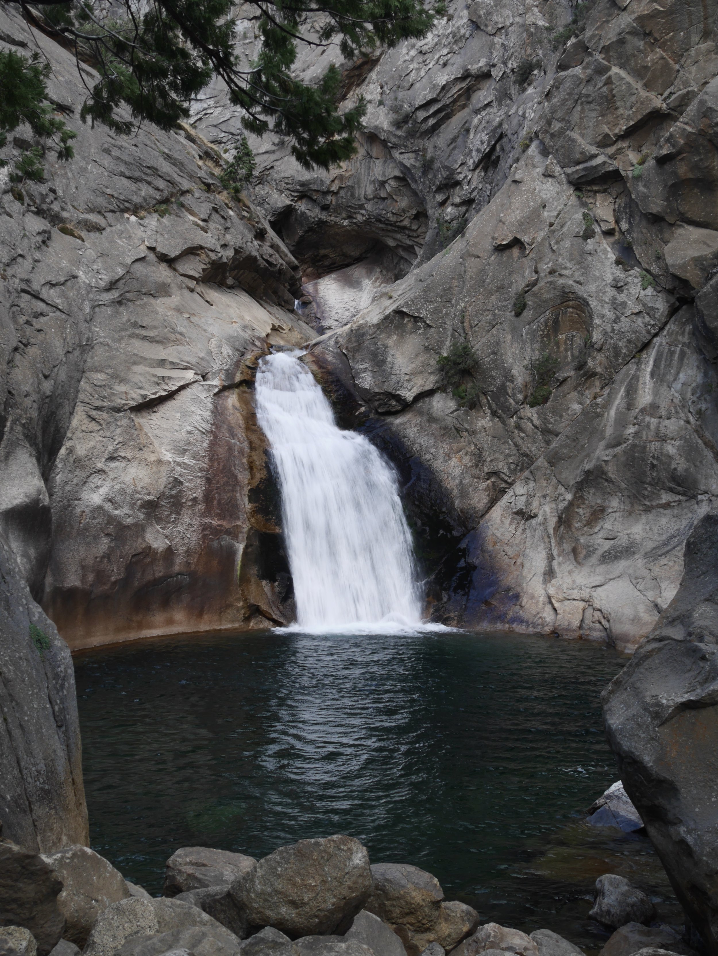
After we got back to the trailhead, we loaded up the car and then drove a short distance to take a look at Roaring River Falls. And since we were on a waterfall kick, we also stopped at Grizzly Falls.

The car we rented seemed to have a fuel gauge that reads high. It still read full for most of the way from Fresno and had barely moved during the drive to Road's End. We decided to fuel up and ended up putting in about five gallons. The gauge was reading ⅞ full, so yes, we would have to be careful about that.
After we got back to our room, we cleaned up, then went up the road to get some dinner. It was a pretty quiet rest of the evening.
Sunday, 9-Oct
Saturday was waterfall day, and Sunday would be big tree day. As we entered the park, there was no line, but the ranger still needed to go fetch a phone to read our pass. We decided to go south from the Kings Canyon entrance and down into Sequoia National Park to walk the Congress Trail, which starts near the General Sherman tree. We expected a crowd but were surprised that a stop opened up almost directly across the access to General Sherman.
There were plenty of signs to what's probably the best-known tree in the park. There were a lot of interpretive signs and even one where you could peer through the other trees to see the very top of General Sherman. It had probably been at least 50 years since I was there last time, but the sign in front of the tree looks just like the photo of young me next to the same sign. The path around the tree takes an odd jog to go around a branch that fell down.
Next up was the Congress Trail. We didn't expect it to be paved, but that did make way-finding easier. A large tree went across one part of the path, but a hole was cut out so we could walk through.
First up was the McKinley tree, which, unlike General Sherman, seems to not be dead at the top. After that was the Senate Group, which is a close-set group of trees. We then went by the House Group. You can see why it's called the Congress Trail. Finally, we saw the President Tree. That tree is the oldest living sequoia (General Sherman is the largest tree by volume).


We decided to go to the Wuksachi Lodge for lunch, where we sat by a huge window with a view of the forest. Since they also served ice cream, we felt the need to stay for dessert.
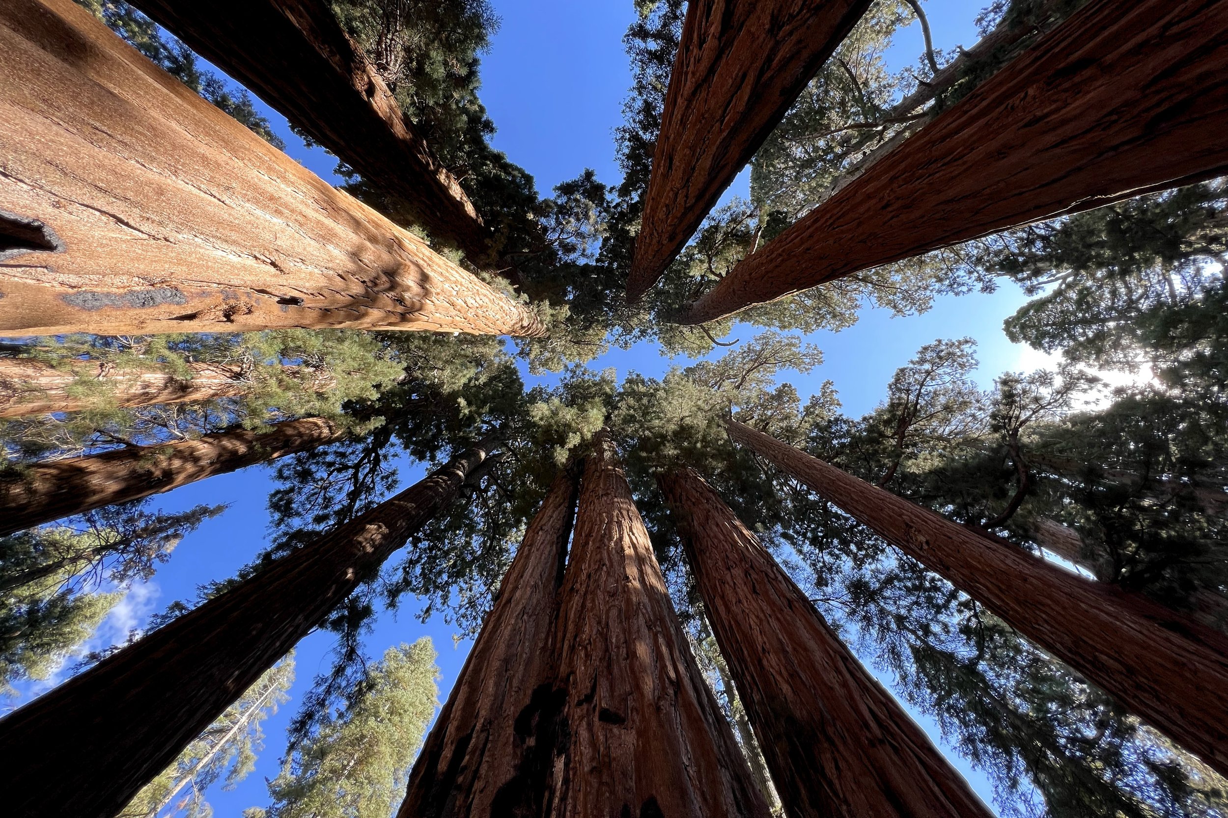
Next up was the Buena Vista Trail. It was only about a mile to the viewpoint, but there would be a bit of climbing while at elevation, starting at 7,100 feet and going to 7,600. Part of the trail went through the remains of a recent fire, but it didn't take us long to get past that. Among the trees were a lot of huge rocks which originally formed underground, shaped by water in the soil, and then exposed by erosion.
When we got to the top, we could look in all directions. We also enjoyed the rocks up there, which are all sorts of shapes. After taking in the view and catching our breath, we went back down to the car.


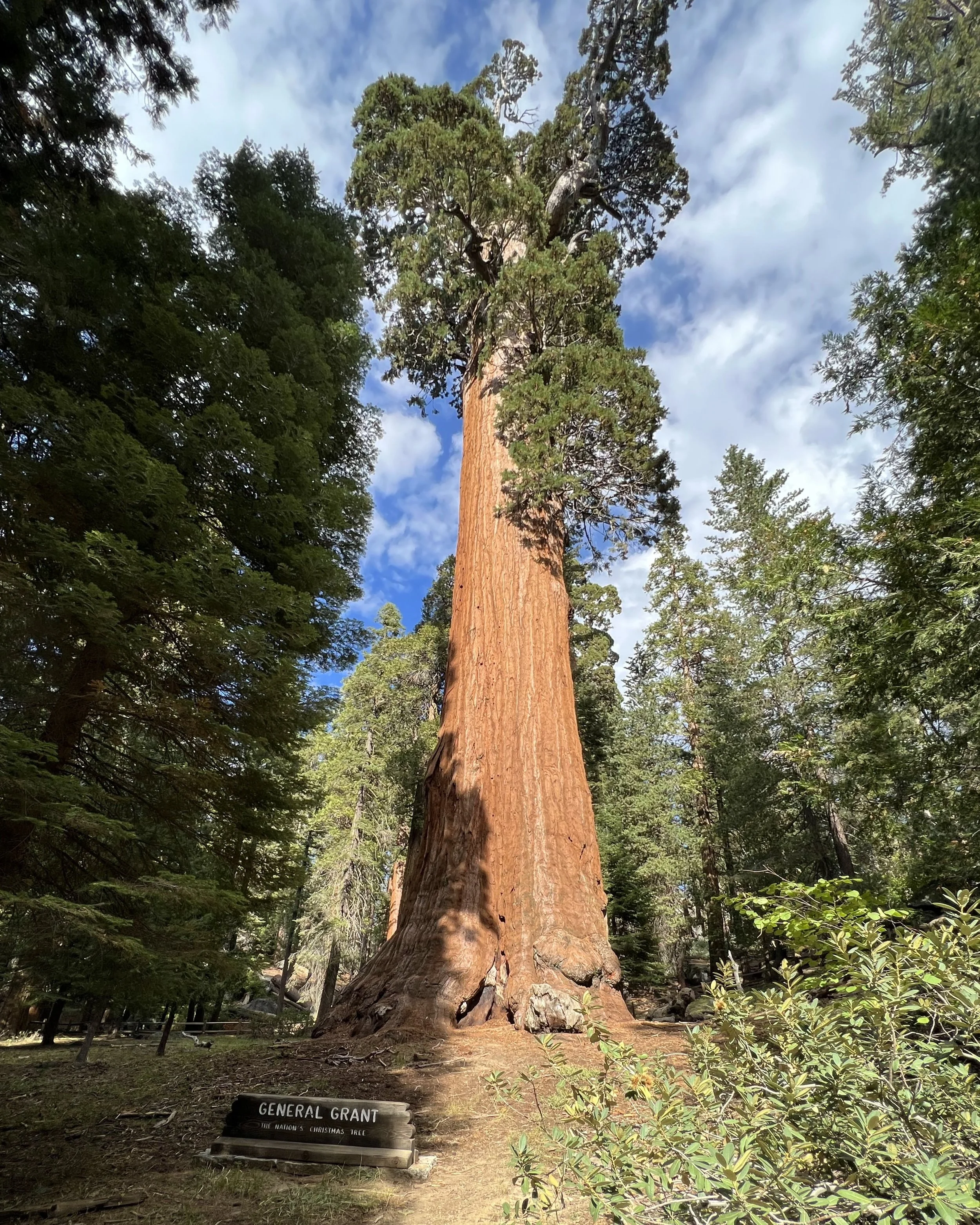
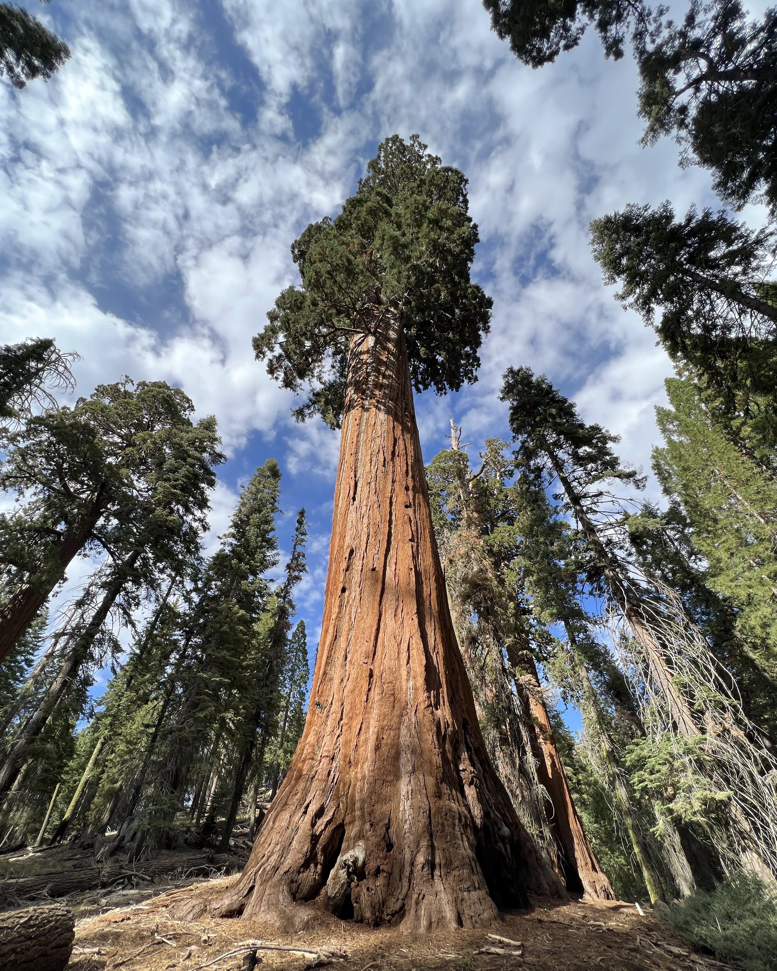
The next stop was Grant Grove. Once again there were a lot of cars, but the lot wasn't full. This was a short loop, so even though we were getting tired, we figured we would be fine. We first saw a hollowed-out tree trunk, then Fallen Monarch. It, along with a shed later on the trail, was used to house workers. Not much further, we caught our first glimpse of General Grant. Like General Sherman, it's not alive at the top but still survives. Further on the trail was the Centennial Stump, the remains of a tree felled in 1875. The outer shell of a slice of the tree was sent to the Philadelphia Centennial Exhibition of 1876, but eastern people didn't believe it was a single tree.
We continued around the trail to the other side of the Fallen Monarch, went around the Lincoln Tree, and then back to the car.


On the way back, we stopped by a store to pick up some groceries for dinner and to fill out what we had for breakfasts and hiking snacks. Then it was back to the room. The owner of the Airbnb had returned, so we chatted for a while.
Monday, 10-Oct
Our last full day in the area, and it was a day for a longer hike. Our final day entering the park, the ranger just looked at our pass and didn’t even scan it.
This time we went back down to Sequoia and past the parking lot for the General Sherman tree. We arrived at an almost empty parking lot to hike the Lakes Trail to Heather Lake. Several people were getting ready for a backpacking trip. Since we started before them, we figured we would be at a slightly faster pace than they would be, so we shouldn't slow them down.
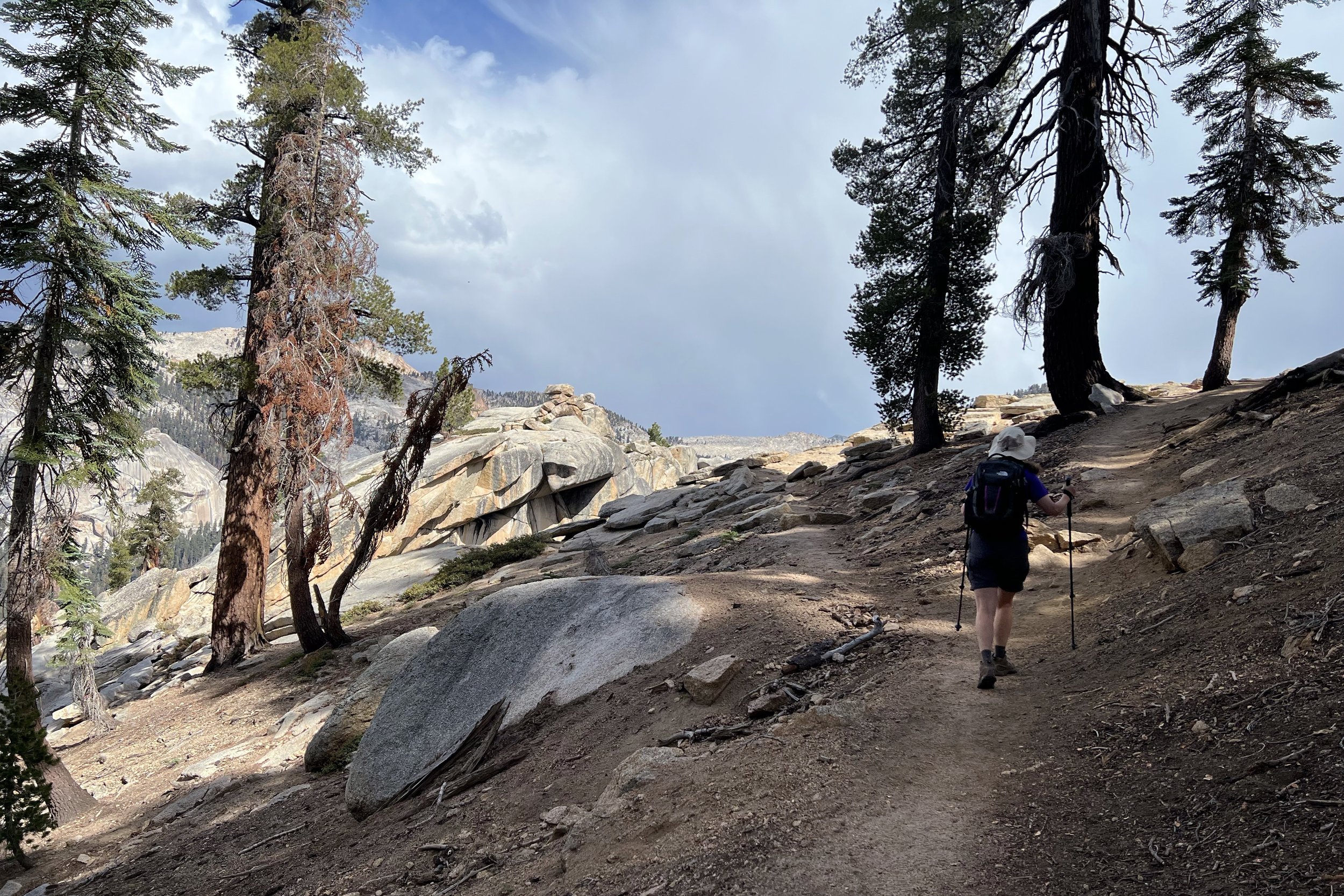
We knew that the trail would be a steady incline. There's one section where we had a choice of going along a ledge with great views (the Watchtower), or higher over the same hill (the Hump). We figured we would do the view first, then see how we felt about the return trip. We were also keeping an eye on the skies since there was a chance of a little bad weather.
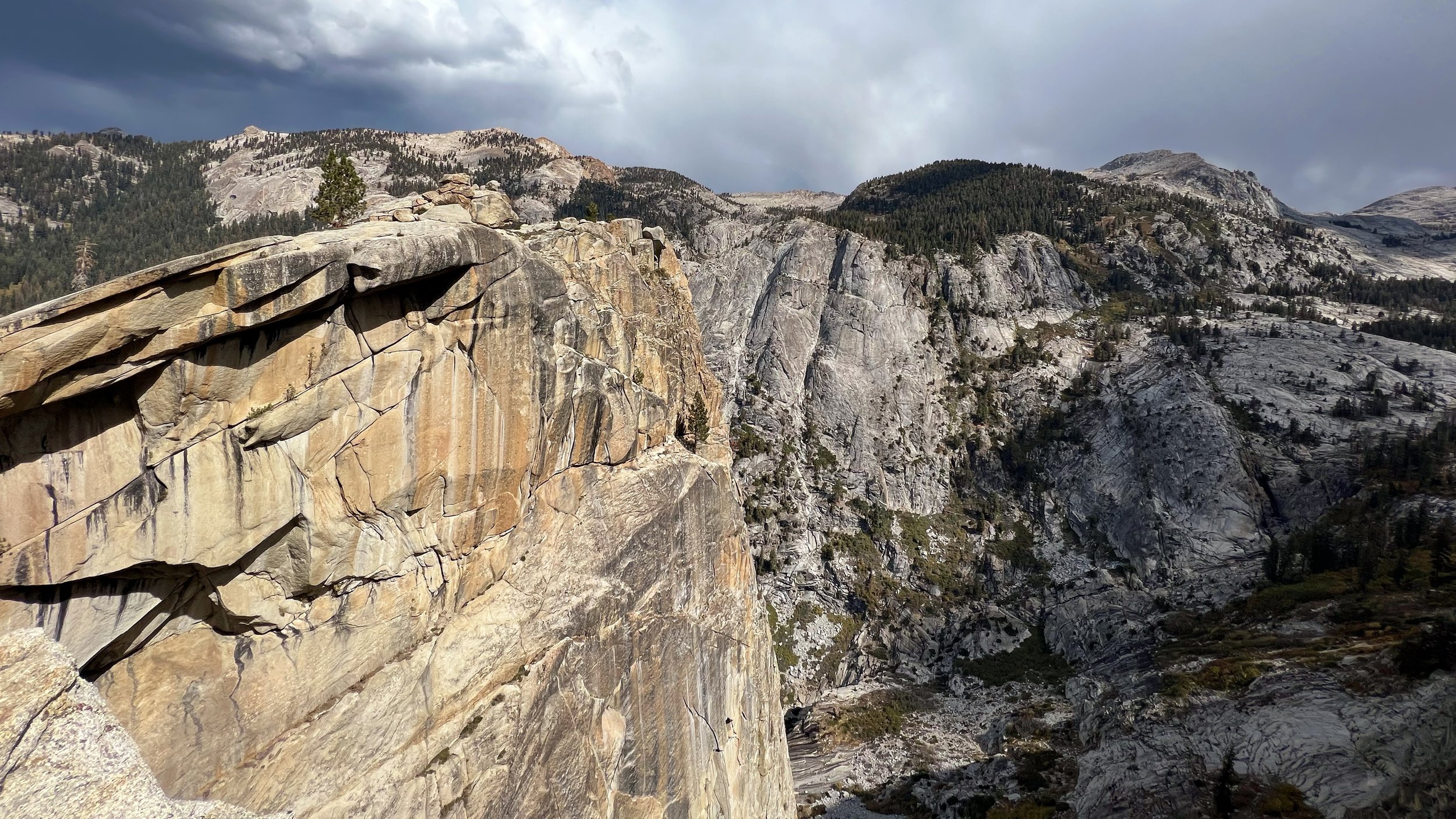
One of the switchbacks on the way up took a sharp turn, but our map showed there was a spur trail that went up the Watchtower, a big hunk of bare rock. I scrambled up there and found a gap where I could look to the other side of the Watchtower. Returning to the trail, we proceeded to get a good look at the Watchtower from the other side. The view was so good, we lingered for quite a while. A small group of hikers almost went right by, but then noticed us taking a look, asking about the view. They were also amazed and were still looking around as we continued on the trail.
After the Watchtower, we started getting views of the Tokopah Valley, which was very expansive. The drop on the side of the trail was quite steep, but there was plenty of room, even when passing people.
We finally met up with the Hump trail just before Heather Lake, and we worked our way to a place with a good view to sit down for lunch. As we were finishing up, we started hearing distant thunder, so we packed everything back up and started back.
Since the Watchtower/Hump junction was near, we needed to decide how to go back. We decided to go back the way we came. We knew the view would be great, although the Hump trail would have given us different things to look at. We would also avoid about 250 feet of gain, offseting the fact that the Hump trail was shorter. Another factor is we were already at about 9,500 feet, so climbing was harder than usual. We could see rain over the hills on the other side of Tokopah Valley, and even saw a bolt of lightning. Since the whole way was mostly a slight downhill, we made pretty good time. We did feel some light misting, but other than that, we avoided the rain.
On the way, we ran into the backpacking group we saw in the parking lot. They seemed to be going at a steady pace, but we also knew their destination was at least another mile beyond ours since there was no camping at Heather Lake.
Interestingly enough, there was a segment of the trail where we received a bit of cell data, probably the only time we had it in the whole park. Most of the cell service wasn't our carrier, so we could have made emergency calls if we needed to.
We also ran across a father/son duo who were doing a lot of off-trail hiking. The father seemed quite knowledgeable about what would be doable by the son, who seemed pretty excited about their hike.
As we neared the trailhead, we saw a pack and trekking poles right next to the trail. We looked around, wondering if it was someone who was in the bushes, but we heard nothing, and that was an odd place to leave things, not to mention it looked like they were dropped quickly. As we were almost at the parking lot, someone was hurrying the other way, clutching a sleeping bag. He asked if his bag was still there, and sounded relieved when we told him we saw it. He said he was glad to have remembered the bag when he did.


On the way back, we picked up a bit more fruit for the morning and some takeout food. It was a bit early for dinner, so we stuck everything into the fridge when we got back to the room. The owner was offering us some eggs from his chicken, so we figured we would be able to use them for breakfast.
Tuesday, 11-Oct
Breakfast was different than usual since we had eggs. We had some English muffins, so I fired up the outdoor cooktop and grilled the muffins on a skillet to toast them a bit. Eggs got fried over easy, then put on top of the muffin halves. That plus our usual yogurt and fruit, and we had plenty of food to keep us going as we drove to Los Angeles.

